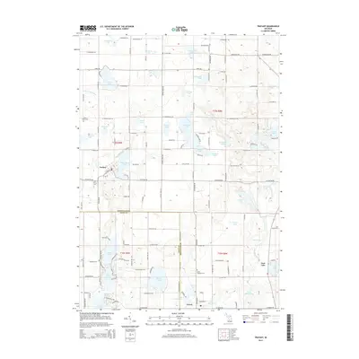
2014 Map of Trufant
USGS Topo · Published 2014About this map
Trufant sits as the primary settlement in this landscape of glacial kettle lakes and winding country roads along the border of Montcalm and Kent Counties. This 2014 survey reveals a dense network of water bodies, including Muskellunge Lake, Cowden Lake, and Maston Lake, which have long defined the recreation and settlement patterns of Maple Valley Township. In the southern portion of the map, the Flat River meanders past the community of Gowen, while the eastern edge is marked by the developed shoreline of Turk Lake.
Find a feature on this map
78 named features on this map. Tap any name to fly to it.
Don’t see what you’re looking for? This feature index may not catch every label — zoom into the map to look around manually.
Map Details
Editions of this 2014 Trufant Map
This is the sole edition of this map. No revisions or reprints were ever made.
Other maps of this area

1954 · Midland
USGS Topo · 1:250,000

1958 · Midland
USGS Topo · 1:250,000

1959 · Midland
USGS Topo · 1:250,000

1959 · Howard City
USGS Topo · 1:62,500

1964 · Six Lakes
USGS Topo · 1:24,000

1964 · Langston
USGS Topo · 1:24,000

1966 · Midland
USGS Topo · 1:250,000

1972 · Greenville West
USGS Topo · 1:24,000
1972 · Greenville East
USGS Topo · 1:24,000
1972 · Evans
USGS Topo · 1:24,000