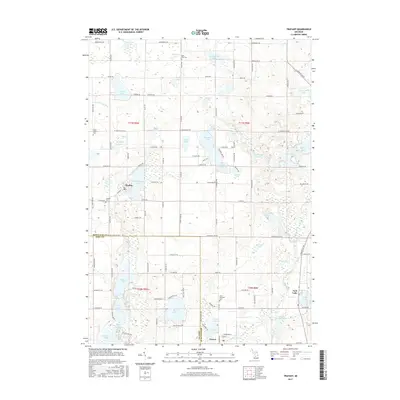
2017 Map of Trufant
USGS Topo · Published 2017About this map
Trufant serves as the central hub of this northern Michigan landscape, situated at the crossroads of Stanton Rd and Co Rd 522. The terrain is defined by an intricate network of glacial lakes and drainage systems, including the notable Muskellunge Lake and the Lovett and Cody Drain. This topography shaped the early development of the region, where small settlements like Gowen and Turk Lake grew alongside these water bodies.
Find a feature on this map
76 named features on this map. Tap any name to fly to it.
Don’t see what you’re looking for? This feature index may not catch every label — zoom into the map to look around manually.
Map Details
Editions of this 2017 Trufant Map
This is the sole edition of this map. No revisions or reprints were ever made.
Other maps of this area

1954 · Midland
USGS Topo · 1:250,000

1958 · Midland
USGS Topo · 1:250,000

1959 · Midland
USGS Topo · 1:250,000

1959 · Howard City
USGS Topo · 1:62,500

1964 · Six Lakes
USGS Topo · 1:24,000

1964 · Langston
USGS Topo · 1:24,000

1966 · Midland
USGS Topo · 1:250,000

1972 · Greenville West
USGS Topo · 1:24,000
1972 · Greenville East
USGS Topo · 1:24,000
1972 · Evans
USGS Topo · 1:24,000