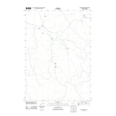
2012 Map of Truman Draw
USGS Topo · Published 2012About this map
Middle Prong Wild Horse Cr winds through this section of Campbell County, carving a landscape defined by an intricate network of drainages and seasonal draws. This early 21st-century survey reveals a territory shaped by ranching and land management, where Middle Prong Rd serves as a primary artery across the high plains. Water is the defining resource here, evidenced by features such as the Gibbons Number 1 Reservoir and Horse Cr in the north. The map documents the specific nomenclature of the local topography, identifying numerous named features such as Truman Draw, Box Elder Draw, and Worley Draw. This record is particularly valuable for understanding the drainage patterns and historical land divisions in a region where named landmarks are often sparse but critical for navigation and property boundary identification.
Find a feature on this map
14 named features on this map. Tap any name to fly to it.
Don’t see what you’re looking for? This feature index may not catch every label — zoom into the map to look around manually.
Map Details
Editions of this 2012 Truman Draw Map
This is the sole edition of this map. No revisions or reprints were ever made.
Other maps of this area

1954 · Gillette
USGS Topo · 1:250,000

1955 · Gillette
USGS Topo · 1:250,000

1958 · Gillette
USGS Topo · 1:250,000

1962 · Gillette
USGS Topo · 1:250,000

1971 · Larey Draw
USGS Topo · 1:24,000

1971 · Wildcat
USGS Topo · 1:24,000

1971 · Oriva NW
USGS Topo · 1:24,000

1971 · Recluse
USGS Topo · 1:24,000
1971 · Spotted Horse
USGS Topo · 1:24,000
1971 · Truman Draw
USGS Topo · 1:24,000