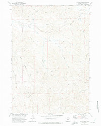
1971 Map of Truman Draw
USGS Topo · Published 1975About this map
The Middle Prong Wild Horse Creek and its many tributaries define this Campbell County landscape, showing the drainage patterns of the Missouri River Basin during the early 1970s. The area is characterized by an extensive network of ephemeral watercourses, including Truman Draw, Box Elder Draw, and Fitch Draw. Human activity in this rural Wyoming setting is evidenced by resource extraction and land management, with several scattered locations marked as Drill Hole, a Well, and a Mine near the North Fork Wildcat Cr. The presence of the Highline road in the north and various Jeep Trail paths suggests a terrain utilized for ranching and energy exploration. This map captures the region's topographical transition before modern intensification, where local landmarks like Gene Draw and Worley Draw served as primary navigational points for those working the land.
Find a feature on this map
20 named features on this map. Tap any name to fly to it.
Don’t see what you’re looking for? This feature index may not catch every label — zoom into the map to look around manually.
Map Details
Editions of this 1971 Truman Draw Map
This is the sole edition of this map. No revisions or reprints were ever made.
Other maps of this area

1954 · Gillette
USGS Topo · 1:250,000

1955 · Gillette
USGS Topo · 1:250,000

1958 · Gillette
USGS Topo · 1:250,000

1962 · Gillette
USGS Topo · 1:250,000

1971 · Larey Draw
USGS Topo · 1:24,000

1971 · Wildcat
USGS Topo · 1:24,000

1971 · Oriva NW
USGS Topo · 1:24,000

1971 · Recluse
USGS Topo · 1:24,000
1971 · Spotted Horse
USGS Topo · 1:24,000
1972 · Echeta
USGS Topo · 1:24,000