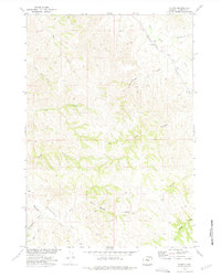
1972 Map of Echeta
USGS Topo · Published 1975About this map
Echeta serves as a small rail-side anchor in this cattle-and-resource landscape of Campbell County, Wyoming. Established along the Burlington Northern line, the settlement is surrounded by a network of drainage systems including Wild Horse Creek and the meandering Fortification Creek. The topography is defined by the sharp draws and canyons typical of the region, such as Schoolhouse Draw and Snell Canyon, which break the high plains terrain. Industrial activity is evident through the presence of several Mines and an Oil Well near the rail corridor, marking the era's reliance on mineral extraction and energy development. Small ranching or utility routes, labeled as Jeep Trails, wind through the more remote sections like Soft Water Draw, providing a glimpse into the logistical challenges of the 1970s western frontier.
Find a feature on this map
19 named features on this map. Tap any name to fly to it.
Don’t see what you’re looking for? This feature index may not catch every label — zoom into the map to look around manually.
Map Details
Editions of this 1972 Echeta Map
This is the sole edition of this map. No revisions or reprints were ever made.
Other maps of this area

1954 · Gillette
USGS Topo · 1:250,000

1955 · Sheridan
USGS Topo · 1:250,000

1955 · Gillette
USGS Topo · 1:250,000

1958 · Gillette
USGS Topo · 1:250,000

1958 · Sheridan
USGS Topo · 1:250,000

1962 · Gillette
USGS Topo · 1:250,000

1962 · Sheridan
USGS Topo · 1:250,000
1971 · Truman Draw
USGS Topo · 1:24,000
1972 · Carr Draw
USGS Topo · 1:24,000
1972 · Jeffers Draw
USGS Topo · 1:24,000