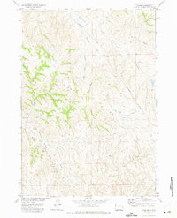
1972 Map of Carr Draw
USGS Topo · Published 1975About this map
Kinney Divide dominates the central topography of this Wyoming landscape, acting as a high point for a complex drainage system during the early 1970s. The map illustrates a region defined by its watercourses, where names like Carr Draw, Antelope Draw, and McLaughlin Draw suggest a terrain carved by intermittent flow. Grounded in the development of the Missouri River Basin, the survey captures the area just as energy exploration began to mark the surface. Numerous industrial markers including Oil Well locations, Well sites, and Drill Hole labels appear across the south and west, particularly near Barber Creek. This intersection of traditional ranchland travel, represented by the Montgomery Road and various Jeep Trails, with burgeoning subsurface extraction reflects a period of significant transition in Campbell County.
Find a feature on this map
17 named features on this map. Tap any name to fly to it.
Don’t see what you’re looking for? This feature index may not catch every label — zoom into the map to look around manually.
Map Details
Editions of this 1972 Carr Draw Map
This is the sole edition of this map. No revisions or reprints were ever made.
Other maps of this area

1954 · Gillette
USGS Topo · 1:250,000

1955 · Sheridan
USGS Topo · 1:250,000

1955 · Gillette
USGS Topo · 1:250,000

1958 · Gillette
USGS Topo · 1:250,000

1958 · Sheridan
USGS Topo · 1:250,000

1962 · Gillette
USGS Topo · 1:250,000

1962 · Sheridan
USGS Topo · 1:250,000
1971 · Scott Dam
USGS Topo · 1:24,000
1971 · Morgan Draw
USGS Topo · 1:24,000
1972 · Laskie Draw
USGS Topo · 1:24,000