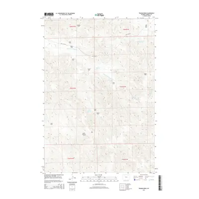
2015 Map of Truman Draw
USGS Topo · Published 2015About this map
Truman Draw defines the high plains topography of Campbell County in this 2015 U.S. Geological Survey representation. The landscape is deeply carved by a network of drainage features, or draws, including Gene Draw, Fitch Draw, and Worley Draw, which underscore the region's reliance on intermittent water sources. Water management is central to the area's utility, evidenced by several small-scale containment features like the P R Reservoir, Gibbons Number 1 Reservoir, and Scott Storage Reservoir. These man-made structures collect runoff from watercourses such as Middle Prong Wild Horse Cr and Horse Cr to support local agricultural and livestock needs. Settlement is sparse, with infrastructure limited to rural routes like Middle Prong Rd, which provides access across the various townships and ranges that divide this open ranching country.
Find a feature on this map
26 named features on this map. Tap any name to fly to it.
Don’t see what you’re looking for? This feature index may not catch every label — zoom into the map to look around manually.
Map Details
Editions of this 2015 Truman Draw Map
This is the sole edition of this map. No revisions or reprints were ever made.
Other maps of this area

1954 · Gillette
USGS Topo · 1:250,000

1955 · Gillette
USGS Topo · 1:250,000

1958 · Gillette
USGS Topo · 1:250,000

1962 · Gillette
USGS Topo · 1:250,000

1971 · Larey Draw
USGS Topo · 1:24,000

1971 · Wildcat
USGS Topo · 1:24,000

1971 · Oriva NW
USGS Topo · 1:24,000

1971 · Recluse
USGS Topo · 1:24,000
1971 · Spotted Horse
USGS Topo · 1:24,000
1971 · Truman Draw
USGS Topo · 1:24,000