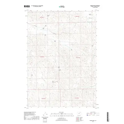
2017 Map of Truman Draw
USGS Topo · Published 2017About this map
Middle Prong Wild Horse Cr carves a winding path through this corner of Campbell County, defining a landscape dominated by complex drainage systems and intermittent water sources. The area is characterized by an intricate network of named draws, such as Truman Draw, Lake Draw, and Worley Draw, which illustrate the local reliance on specific topographical features for orientation and water management in a dry environment. The presence of Gibbons Number 1 Reservoir and several windmill-related features, including South Windmill Draw, suggests the vital role of water infrastructure in supporting ranching or agricultural operations in this part of Wyoming. Human presence is marked by Middle Prong Rd, which provides access across the northern terrain, linking various points such as Harper Draw and Fitch Draw within the townships of T54N and T53N.
Find a feature on this map
24 named features on this map. Tap any name to fly to it.
Don’t see what you’re looking for? This feature index may not catch every label — zoom into the map to look around manually.
Map Details
Editions of this 2017 Truman Draw Map
This is the sole edition of this map. No revisions or reprints were ever made.
Other maps of this area

1954 · Gillette
USGS Topo · 1:250,000

1955 · Gillette
USGS Topo · 1:250,000

1958 · Gillette
USGS Topo · 1:250,000

1962 · Gillette
USGS Topo · 1:250,000

1971 · Larey Draw
USGS Topo · 1:24,000

1971 · Wildcat
USGS Topo · 1:24,000

1971 · Oriva NW
USGS Topo · 1:24,000

1971 · Recluse
USGS Topo · 1:24,000
1971 · Spotted Horse
USGS Topo · 1:24,000
1971 · Truman Draw
USGS Topo · 1:24,000