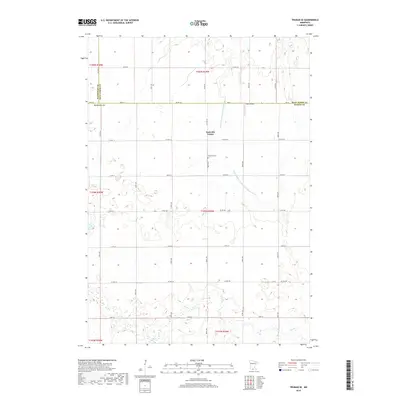
2019 Map of Truman SE
USGS Topo · Published 2019About this map
Nashville Center stands at the heart of this rural Martin County landscape, serving as a focal point for the surrounding agricultural tracts. The map reveals a highly engineered water management system essential for local farming, defined by extensive channels like Judicial Ditch Number Eightythree and Judicial Ditch Number One Hundred Six. These man-made waterways intersect the natural drainage of Elm Cr, illustrating the intensive land modification required to sustain the region's productivity. Genealogists will find the Nashville Cem centrally located near the settlement, a significant landmark for tracing local family roots. Further north, the private Burk Airport indicates the role of general aviation in this prairie environment. The rectangular grid of county roads, including Co HWY 52 and Co HWY 44, provides the framework for the modern township structure.
Find a feature on this map
42 named features on this map. Tap any name to fly to it.
Don’t see what you’re looking for? This feature index may not catch every label — zoom into the map to look around manually.
Map Details
Editions of this 2019 Truman SE Map
This is the sole edition of this map. No revisions or reprints were ever made.
Other maps of this area

1954 · Fairmont
USGS Topo · 1:250,000

1958 · Fairmont
USGS Topo · 1:250,000

1967 · Truman
USGS Topo · 1:24,000

1967 · Truman SE
USGS Topo · 1:24,000

1967 · Winnebago
USGS Topo · 1:24,000

1967 · Willow Creek
USGS Topo · 1:24,000

1967 · Lewisville
USGS Topo · 1:24,000

1967 · Granada
USGS Topo · 1:24,000

1967 · Huntley
USGS Topo · 1:24,000
1967 · Amboy
USGS Topo · 1:24,000