
1967 Map of Truman SE
USGS Topo · Published 1968About this map
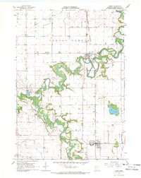
The agricultural landscape of south-central Minnesota is defined here by a sophisticated network of drainage infrastructure, with Judicial Ditch No 85, Judicial Ditch No 82, and Judicial Ditch No 116 channeling water across the township boundaries of Pleasant Mound, Nashville, and Westford. This 1967 survey reveals the quiet hubs of rural life, anchored by Nashville Center and the Townhall, while the Nashville Cem and Brainard Ch mark established community landmarks. In the southern portion of the quadrangle, the meandering course of Elm Creek contrasts with the rigid geometry of the surrounding section lines and a prominent Pipeline. Economic activity is visible through a scattered Landing Strip and industrial Gravel Pits in the northeast, providing a clear view of the region's mid-century rural development and land use patterns.
Find a feature on this map
20 named features on this map. Tap any name to fly to it.
Don’t see what you’re looking for? This feature index may not catch every label — zoom into the map to look around manually.
Map Details
Editions of this 1967 Truman SE Map
This is the sole edition of this map. No revisions or reprints were ever made.
Other maps of this area

1954 · Fairmont
USGS Topo · 1:250,000

1958 · Fairmont
USGS Topo · 1:250,000

1967 · Truman
USGS Topo · 1:24,000

1967 · Winnebago
USGS Topo · 1:24,000

1967 · Willow Creek
USGS Topo · 1:24,000

1967 · Lewisville
USGS Topo · 1:24,000

1967 · Granada
USGS Topo · 1:24,000

1967 · Huntley
USGS Topo · 1:24,000
1967 · Amboy
USGS Topo · 1:24,000

1967 · Fairmont
USGS Topo · 1:24,000