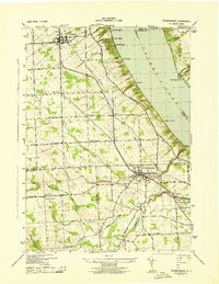
1943 Map of Trumansburg
USGS Topo · Published 1943About this map
Cayuga Lake forms the eastern boundary of this mid-century landscape, where the steep bluffs of the Finger Lakes region are deeply incised by drainages like Taughannock Creek and Trumansburg Creek. The village of Trumansburg serves as a primary hub, situated near the transition from upland farmsteads to the dramatic lakeside terrain of Taughannock Falls State Park. Further north, Interlaken sits along the Lehigh Valley railroad line, which skirts the lake's western shore, connecting several small agricultural hamlets.
Find a feature on this map
41 named features on this map. Tap any name to fly to it.
Don’t see what you’re looking for? This feature index may not catch every label — zoom into the map to look around manually.
Map Details
Editions of this 1943 Trumansburg Map
This is the sole edition of this map. No revisions or reprints were ever made.
Other maps of this area

1893 · Ithaca
USGS Topo · 1:62,500

1895 · Ithaca
USGS Topo · 1:62,500

1898 · Watkins Glen
USGS Topo · 1:62,500

1901 · Watkins
USGS Topo · 1:62,500

1902 · Genoa
USGS Topo · 1:62,500

1902 · Ovid
USGS Topo · 1:62,500

1905 · Watkins Glen
USGS Topo · 1:125,000

1942 · Ovid
USGS Topo · 1:31,680

1942 · Ludlowville
USGS Topo · 1:24,000

1942 · Lodi
USGS Topo · 1:24,000