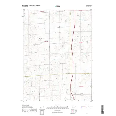
2018 Map of Truro
USGS Topo · Published 2018About this map
Truro serves as the primary hub of this Iowa landscape, where the intersection of three counties—Madison, Warren, and Clarke—dictates the local geography. The area is defined by a dense network of country roads following the section lines of the Public Land Survey System, though the terrain is naturally carved by the S River and its various tributaries. For family history researchers, the map identifies several rural burying grounds including Young Cem, Farson Cem, and Hartman Cem, many of which are tucked away from the main thoroughfares. The southern portion of the sheet shows the headwaters of Hanner Cr and Walnut Cr, while the northern section is dominated by the winding path of Broadhorn Cr. This modern survey details how Interstate 35 bisects the eastern townships, creating a sharp contrast between modern high-speed transit and the older grid of gravel roads like Settlers Trl.
Find a feature on this map
79 named features on this map. Tap any name to fly to it.
Don’t see what you’re looking for? This feature index may not catch every label — zoom into the map to look around manually.
Map Details
Editions of this 2018 Truro Map
This is the sole edition of this map. No revisions or reprints were ever made.
Other maps of this area

1931 · Indianola
USGS Topo · 1:62,500

1950 · New Virginia
USGS Topo · 1:62,500

1951 · Osceola
USGS Topo · 1:62,500

1951 · St. Charles
USGS Topo · 1:62,500

1952 · New Virginia
USGS Topo · 1:62,500

1954 · Des Moines
USGS Topo · 1:250,000

1956 · Des Moines
USGS Topo · 1:250,000

1957 · Des Moines
USGS Topo · 1:250,000

1969 · Des Moines
USGS Topo · 1:250,000
1983 · St. Charles
USGS Topo · 1:24,000