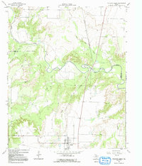
1966 Map of Truscott North
USGS Topo · Published 1991About this map
The settlement of Truscott sits near the southern boundary of this West Texas landscape, positioned within a drainage system defined by the meandering North Wichita River. Surveyed in the mid-1960s, the terrain is deeply etched by a network of seasonal watercourses including Buffalo Creek, Salt Flat Creek, and Bluff Creek, reflecting the erosive power of occasional rains on the regional geology.
Find a feature on this map
13 named features on this map. Tap any name to fly to it.
Don’t see what you’re looking for? This feature index may not catch every label — zoom into the map to look around manually.
Map Details
Editions of this 1966 Truscott North Map
2 editions found
Other maps of this area

1954 · Wichita Falls
USGS Topo · 1:250,000

1958 · Wichita Falls
USGS Topo · 1:250,000

1966 · Truscott North
USGS Topo · 1:24,000

1966 · Truscott South
USGS Topo · 1:24,000

1966 · Halsell Ranch
USGS Topo · 1:24,000

1966 · Gilliland
USGS Topo · 1:24,000

1966 · Big Four Ranch
USGS Topo · 1:24,000

1966 · Crowell
USGS Topo · 1:24,000

1966 · Maverick Flat
USGS Topo · 1:24,000
1968 · Boiling Spring
USGS Topo · 1:24,000