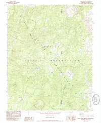
1982 Map of Tsaile Butte
USGS Topo · Published 1986About this map
The Chuska Mountains and Tunitcha Mountains converge in this high-altitude 1982 survey of the Navajo Indian Reservation. The terrain is defined by dramatic elevation changes, centered on the prominent landmark of Tsaile Butte. Water systems are critical to this landscape, with Tsaile Creek and Wheatfields Creek carving deep drainage patterns through the high plateaus.
Find a feature on this map
11 named features on this map. Tap any name to fly to it.
Don’t see what you’re looking for? This feature index may not catch every label — zoom into the map to look around manually.
Map Details
Editions of this 1982 Tsaile Butte Map
2 editions found
Other maps of this area

1889 · Chaco
USGS Topo · 1:250,000

1892 · Chaco
USGS Topo · 1:250,000

1892 · Canyon De Chelly
USGS Topo · 1:250,000

1953 · Sanostee
USGS Topo · 1:62,500

1954 · Shiprock
USGS Topo · 1:250,000
1955 · Sonsala Butte 1 NW
USGS Topo · 1:24,000

1955 · Sonsala Butte 4 NW
USGS Topo · 1:24,000

1955 · Sonsala Butte 1 SE
USGS Topo · 1:24,000
1955 · Sonsala Butte 1 NE
USGS Topo · 1:24,000

1955 · Sonsala Butte 1 SW
USGS Topo · 1:24,000