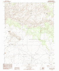
1985 Map of Tse Esgizii
USGS Topo · Published 1985About this map
Navajo Indian Reservation lands in Coconino County define this arid high-desert landscape, dominated by the sprawling Rainbow Plateau and the deeply incised path of Navajo Creek. The map documents a rugged terrain of high-altitude tables and steep canyon walls, where water sources like Bigman Spring and the Water Pockets were critical for survival and land use. Settlement is sparse, represented by the curious notation of The Dam south of Gray Mesa.
Find a feature on this map
13 named features on this map. Tap any name to fly to it.
Don’t see what you’re looking for? This feature index may not catch every label — zoom into the map to look around manually.
Map Details
Editions of this 1985 Tse Esgizii Map
This is the sole edition of this map. No revisions or reprints were ever made.
Other maps of this area

1883 · Marsh Pass
USGS Topo · 1:250,000

1886 · Echo Cliffs
USGS Topo · 1:250,000

1891 · Echo Cliffs
USGS Topo · 1:250,000

1892 · Marsh Pass
USGS Topo · 1:250,000

1954 · Navajo Creek
USGS Topo · 1:62,500

1956 · Marble Canyon
USGS Topo · 1:250,000

1959 · Marble Canyon
USGS Topo · 1:250,000

1961 · Marble Canyon
USGS Topo · 1:250,000
1970 · Chaiyahi Rim SW
USGS Topo · 1:24,000
1970 · Two Red Mesas
USGS Topo · 1:24,000