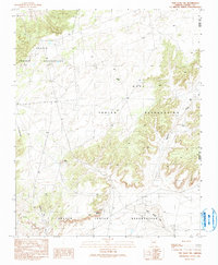
1990 Map of Tsin Naan Tee
USGS Topo · Published 1991About this map
Navajo Indian Reservation lands and the Hopi Indian Reservation converge in this high-desert plateau region of Northeastern Arizona. The landscape is defined by the prominent Tsin Naan Tee formation and the winding path of Beshbito Wash, which cuts through the arid terrain. While the area is largely undeveloped, evidence of resource management and local activity is present in the form of a Gravel Pit and several Check Dam installations designed to control seasonal water flow.
Find a feature on this map
12 named features on this map. Tap any name to fly to it.
Don’t see what you’re looking for? This feature index may not catch every label — zoom into the map to look around manually.
Map Details
Editions of this 1990 Tsin Naan Tee Map
This is the sole edition of this map. No revisions or reprints were ever made.
Other maps of this area

1883 · Tusayan
USGS Topo · 1:250,000

1886 · Tusayan
USGS Topo · 1:250,000

1886 · Fort Defiance
USGS Topo · 1:250,000

1892 · Fort Defiance
USGS Topo · 1:250,000

1947 · Flagstaff
USGS Topo · 1:250,000

1954 · Flagstaff
USGS Topo · 1:250,000

1954 · Gallup
USGS Topo · 1:250,000

1958 · Gallup
USGS Topo · 1:250,000

1958 · Flagstaff
USGS Topo · 1:250,000

1959 · Gallup
USGS Topo · 1:250,000