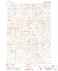
1988 Map of Tub Mountain
USGS Topo · Published 1988About this map
Pine Tree Ridge and Tub Mountain dominate this corner of Malheur County, where water management is central to the arid landscape's utility. A dense network of catchments, including Love Reservoir, Bostic Lake Reservoir, and Alkali Reservoir, indicates a territory heavily engineered for livestock or irrigation. The historic Oregon Trail winds across the northern terrain, a physical legacy of westward migration intersecting with modern industrial infrastructure like the 2 pipelines crossing the eastern ridges. Topographic details reveal numerous prospects and a Gravel Pit, pointing to small-scale mineral exploration. The drainage patterns of Moores Hollow and Jacobsen Fork Gulch illustrate how the geography dictates movement through this high-elevation rangeland.
Find a feature on this map
23 named features on this map. Tap any name to fly to it.
Don’t see what you’re looking for? This feature index may not catch every label — zoom into the map to look around manually.
Map Details
Editions of this 1988 Tub Mountain Map
This is the sole edition of this map. No revisions or reprints were ever made.
Other maps of this area

1950 · Jamieson
USGS Topo · 1:62,500

1951 · Moores Hollow
USGS Topo · 1:24,000

1951 · Malheur Butte
USGS Topo · 1:24,000

1951 · Moores Hollow
USGS Topo · 1:62,500

1951 · Huntington
USGS Topo · 1:62,500

1952 · Olds Ferry
USGS Topo · 1:24,000

1952 · Olds Ferry
USGS Topo · 1:62,500

1952 · Olds Ferry SE
USGS Topo · 1:24,000

1955 · Baker
USGS Topo · 1:250,000

1959 · Baker
USGS Topo · 1:250,000