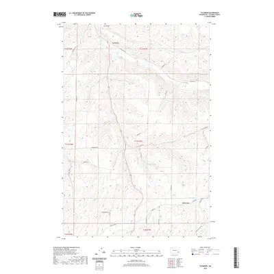
2020 Map of Tucannon
USGS Topo · Published 2020About this map
The Tucannon River carves through the undulating landscape of Columbia County, defining the drainage patterns that shaped local settlement and transportation. In the northern reaches, the small community of Tucannon sits at the junction where Willow Cr meets the main river valley. To the south, the settlement of Whetstone is positioned near Whetstone Cr, illustrating how early pioneers utilized these narrow riparian corridors for access through the high, rolling plateau. Significant topographical landmarks like Dry Hollow and Smith Hollow emphasize the area's complex relief, where early transport routes like Territorial Rd and Tucannon Rd were forced to follow the natural contours of the land. The map reveals a network of rural roads, many named after local families such as Poulsen Rd, Donahue Rd, and Messner Rd, highlighting a deeply rooted agricultural and ranching history.
Find a feature on this map
30 named features on this map. Tap any name to fly to it.
Don’t see what you’re looking for? This feature index may not catch every label — zoom into the map to look around manually.
Map Details
Editions of this 2020 Tucannon Map
This is the sole edition of this map. No revisions or reprints were ever made.
Other maps of this area

1919 · Walla Walla
USGS Topo · 1:125,000

1921 · Walla Walla
USGS Topo · 1:125,000

1937 · Pomeroy
USGS Topo · 1:96,000

1942 · Pomeroy
USGS Topo · 1:125,000

1948 · Starbuck
USGS Topo · 1:62,500

1950 · Starbuck
USGS Topo · 1:62,500

1950 · Hay
USGS Topo · 1:62,500

1952 · Hay
USGS Topo · 1:62,500

1953 · Walla Walla
USGS Topo · 1:250,000

1955 · Pullman
USGS Topo · 1:250,000