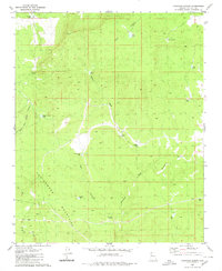
1980 Map of Tuckayou Spring
USGS Topo · Published 1980About this map
The Cottonwood Mountains dominate this high-desert landscape in Mohave County, where water management is the primary evidence of human activity in the late 1970s. A network of cattle tanks and water features such as Hazen Tank, Hells Canyon Tank, and Limestone Spring are scattered across the terrain, illustrating the ranching infrastructure necessary to support livestock in this arid environment. The presence of Maggie Dam and the nearby Maggie Corral Well further emphasizes the reliance on localized water sources.
Find a feature on this map
26 named features on this map. Tap any name to fly to it.
Don’t see what you’re looking for? This feature index may not catch every label — zoom into the map to look around manually.
Map Details
Editions of this 1980 Tuckayou Spring Map
This is the sole edition of this map. No revisions or reprints were ever made.
Other maps of this area

1886 · Diamond Creek
USGS Topo · 1:250,000

1892 · Diamond Creek
USGS Topo · 1:250,000

1948 · Williams
USGS Topo · 1:250,000

1954 · Williams
USGS Topo · 1:250,000

1956 · Williams
USGS Topo · 1:250,000

1960 · Williams
USGS Topo · 1:250,000

1961 · Williams
USGS Topo · 1:250,000
1968 · Truxton
USGS Topo · 1:24,000
1968 · Tin Mountain
USGS Topo · 1:24,000
1968 · Valentine SE
USGS Topo · 1:24,000