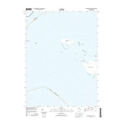
2015 Map of Tuckernuck Island
USGS Topo · Published 2015About this map
Tuckernuck Island sits at the eastern edge of this coastal survey, where the shifting sands and shoals of the Atlantic Ocean define the maritime landscape. This 2015 study captures the low-lying geography of the region, including the isolated Muskeget Island Airport and the protected waters of North Pond. The map reveals the intricate bathymetry and geological features that surround the island, such as Tuckernuck Bank and Bass Ledge. The boundary lines between Dukes County and Nantucket County pass through these waters, illustrating the jurisdictional divide in this thin strip of Massachusetts coastline. Geologists and local historians can use this data to observe coastal morphology and the placement of remote navigation points like Muskeget Rock.
Find a feature on this map
11 named features on this map. Tap any name to fly to it.
Don’t see what you’re looking for? This feature index may not catch every label — zoom into the map to look around manually.
Map Details
Editions of this 2015 Tuckernuck Island Map
This is the sole edition of this map. No revisions or reprints were ever made.
Other maps of this area

1887 · Muskeget
USGS Topo · 1:62,500

1889 · Muskeget
USGS Topo · 1:62,500

1893 · Muskeget
USGS Topo · 1:62,500

1899 · Muskeget
USGS Topo · 1:62,500

1942 · Nantucket
USGS Topo · 1:125,000

1944 · Tuckernuck Island
USGS Topo · 1:31,680

1947 · Providence
USGS Topo · 1:250,000

1948 · Providence
USGS Topo · 1:250,000
1951 · Tuckernuck Island
USGS Topo · 1:31,680

1957 · Providence
USGS Topo · 1:250,000