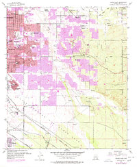
1957 Map of Tucson East
USGS Topo · Published 1977About this map
Tucson expands eastward toward the foothills in this mid-century survey, revealing a landscape defined by rapid residential growth and specialized institutions. The sheet identifies a high concentration of educational and religious sites, ranging from St Josephs Academy and the Reina Cleri Seminary to niche institutions like The Abbie Loveland Tuller School. To the south, the massive footprint of Davis Monthan Air Force Base dominates the terrain, complete with its Landing Field and proximity to the Southern Pacific Railroad Grade.
Find a feature on this map
49 named features on this map. Tap any name to fly to it.
Don’t see what you’re looking for? This feature index may not catch every label — zoom into the map to look around manually.
Map Details
Editions of this 1957 Tucson East Map
4 editions found
Other maps of this area

1904 · Tucson
USGS Topo · 1:125,000

1905 · Tucson
USGS Topo · 1:125,000

1948 · Tucson
USGS Topo · 1:62,500

1956 · Tucson
USGS Topo · 1:250,000

1957 · Tucson East
USGS Topo · 1:24,000

1957 · Bellota Ranch
USGS Topo · 1:62,500

1957 · Tucson
USGS Topo · 1:24,000

1957 · Tucson
USGS Topo · 1:62,500

1957 · Rincon Valley
USGS Topo · 1:62,500

1957 · Sabino Canyon
USGS Topo · 1:24,000