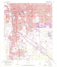
1957 Map of Tucson
USGS Topo · Published 1973About this map
Davis Monthan Air Force Base dominates the eastern landscape of this mid-century survey, illustrating the significant military and aviation presence that defined the city's post-war expansion. The map details a dense network of educational and social infrastructure, ranging from the Pascua Yaqui Indian Village and Polo Village to dozens of neighborhood institutions like Catalina High Sch and the Arizona State School.
Find a feature on this map
78 named features on this map. Tap any name to fly to it.
Don’t see what you’re looking for? This feature index may not catch every label — zoom into the map to look around manually.
Map Details
Editions of this 1957 Tucson Map
3 editions found

Other maps of this area

1904 · Tucson
USGS Topo · 1:125,000

1905 · Tucson
USGS Topo · 1:125,000

1925 · San Xavier
USGS Topo · 1:62,500

1934 · Tucson Mountains
USGS Topo · 1:125,000

1943 · San Xavier Mission
USGS Topo · 1:62,500

1947 · Cortaro
USGS Topo · 1:62,500

1948 · Tucson
USGS Topo · 1:62,500

1956 · Tucson
USGS Topo · 1:250,000

1957 · Tucson East
USGS Topo · 1:24,000

1957 · San Xavier Mission
USGS Topo · 1:62,500