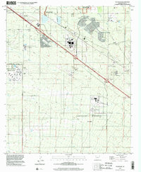
1996 Map of Tucson SE
USGS Topo · Published 2002About this map
The southeastern outskirts of the Tucson Corporate Boundary show a landscape dominated by large-scale institutional and municipal footprints in the late twentieth century. Significant land use is dedicated to the Arizona State Prison Complex - Tucson and the Federal Correctional Institution, alongside the expansive Davis - Monthan Air Force Base to the north. These facilities represent the southward expansion of the city's infrastructure during a period of steady desert growth.
Find a feature on this map
25 named features on this map. Tap any name to fly to it.
Don’t see what you’re looking for? This feature index may not catch every label — zoom into the map to look around manually.
Map Details
Editions of this 1996 Tucson SE Map
This is the sole edition of this map. No revisions or reprints were ever made.
Other maps of this area

1904 · Patagonia
USGS Topo · 1:125,000

1904 · Tucson
USGS Topo · 1:125,000

1905 · Patagonia
USGS Topo · 1:125,000

1905 · Tucson
USGS Topo · 1:125,000

1926 · Helvetia
USGS Topo · 1:62,500

1948 · Tucson
USGS Topo · 1:62,500

1956 · Nogales
USGS Topo · 1:250,000

1956 · Tucson
USGS Topo · 1:250,000

1957 · Tucson East
USGS Topo · 1:24,000

1957 · Tucson
USGS Topo · 1:24,000