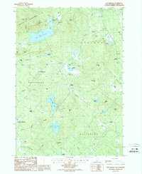
1987 Map of Tuftonboro
USGS Topo · Published 1987About this map
The Ossipee Mountains dominate the northwestern landscape of this region, casting shadows over a network of glacial ponds and small rural hubs in Carroll County. Small settlements such as Center Tuftonboro, Water Village, and Chickville are linked by winding roads that navigate around the prominent heights of Canaan Mtn and Sentinel Mtn. The hydrology of the area is particularly well-defined, featuring the massive Dan Hole Pond and the twin basins of Upper Beech Pond and Lower Beech Pond, which feed into various brooks like Nineteenmile Brook and Whitten Brook.
Find a feature on this map
56 named features on this map. Tap any name to fly to it.
Don’t see what you’re looking for? This feature index may not catch every label — zoom into the map to look around manually.
Map Details
Editions of this 1987 Tuftonboro Map
This is the sole edition of this map. No revisions or reprints were ever made.
Other maps of this area

1909 · Winnepesaukee
USGS Topo · 1:62,500

1928 · Wolfeboro
USGS Topo · 1:62,500

1930 · Ossipee Lake
USGS Topo · 1:62,500

1931 · Mt. Chocorua
USGS Topo · 1:62,500

1949 · Portland
USGS Topo · 1:250,000

1956 · Winnipesaukee
USGS Topo · 1:62,500

1956 · Portland
USGS Topo · 1:250,000

1958 · Ossipee Lake
USGS Topo · 1:62,500

1958 · Wolfeboro
USGS Topo · 1:62,500

1958 · Mt. Chocorua
USGS Topo · 1:62,500