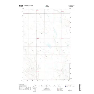
2020 Map of Tule Lake
USGS Topo · Published 2020About this map
Tule Lake and Fifteen Mile Lake serve as the primary hydrologic landmarks in this section of Blaine County, where the high plains landscape is defined by drainage patterns and intermittent water sources. The terrain is structured by the southward flow of Fifteenmile Cr and the Northwest Fork Thirtymile Cr, which carve distinct coulees through the townships. Human impact on the land is represented primarily by the rectilinear Public Land Survey System and a sparse network of section roads, including Zurich Canadian Rd and Cherry Ridge Rd. This area reflects the modern ranching and agricultural character of northern Montana, where vast tracts are organized into townships such as t34n r20e and t34n r21e, illustrating the scale of rural land management and the importance of isolated basins like the namesake Tule Lake.
Find a feature on this map
12 named features on this map. Tap any name to fly to it.
Don’t see what you’re looking for? This feature index may not catch every label — zoom into the map to look around manually.
Map Details
Editions of this 2020 Tule Lake Map
This is the sole edition of this map. No revisions or reprints were ever made.
Other maps of this area

1904 · Chinook
USGS Topo · 1:62,500

1905 · Harlem
USGS Topo · 1:62,500

1912 · Zurich
USGS Topo · 1:125,000

1913 · Cherry Ridge
USGS Topo · 1:125,000

1953 · Havre
USGS Topo · 1:250,000

1957 · Havre
USGS Topo · 1:250,000

1958 · Havre
USGS Topo · 1:250,000

1964 · Rabbit Hills
USGS Topo · 1:24,000
1964 · Fort Belknap Siding
USGS Topo · 1:24,000
1964 · Chinook
USGS Topo · 1:24,000