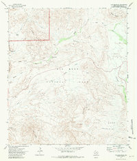
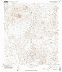
1971 Map of Tule Mountain
USGS Topo · Published 1981About this map
Big Bend National Park defines this arid landscape, documented here just as modern wilderness management was taking firm hold in Brewster County. The presence of the Maverick Ranger Sta near the western boundary and the Apache Canyon Trail (Pack) to the southeast suggests a topography where travel remained restricted to established routes and pack trails. Water sources are the critical landmarks for this era, with named points like Bitter Spring, Indian Head Spring, and Tinaja Spring serving as vital hubs for both natural life and earlier human activity. The map reveals a land structured by immense geological features, from the heights of Dogie Mountain and Maverick Mountain to the broad expanse of Burro Mesa. A lone Corral near the southern edge remains as a physical artifact of the region's ranching heritage within the park's protected limits.
Find a feature on this map
21 named features on this map. Tap any name to fly to it.
Don’t see what you’re looking for? This feature index may not catch every label — zoom into the map to look around manually.
Map Details
Editions of this 1971 Tule Mountain Map
3 editions found
Other maps of this area

1903 · Chisos Mountains
USGS Topo · 1:125,000

1903 · Terlingua
USGS Topo · 1:125,000

1904 · Terlingua
USGS Topo · 1:125,000

1905 · Chisos Mountains
USGS Topo · 1:125,000

1959 · Emory Peak
USGS Topo · 1:250,000

1965 · Emory Peak
USGS Topo · 1:250,000

1971 · Terlingua
USGS Topo · 1:24,000

1971 · Cerro Castellan
USGS Topo · 1:24,000
1971 · Christmas Mountians
USGS Topo · 1:24,000
1971 · Hen Egg Mountain
USGS Topo · 1:24,000