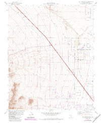
1974 Map of Tule Springs Park
USGS Topo · Published 1984About this map
Floyd R Lamb State Park anchors the eastern edge of this landscape, marking a point where the urban expansion of Nevada’s largest city meets the arid basin. The Las Vegas Corporate Boundary cuts across the alluvial fans, showing the northward reach of the city’s limits during the early 1980s. To the northeast, the Desert National Wildlife Range preserves a vast stretch of the Mojave environment, while the presence of a Railroad Grade and numerous Gravel Pits points to the infrastructure and material demands of a growing desert metropolis. The terrain is crisscrossed by a Jeep Trail and dotted with several Prospects, reflecting a history of small-scale exploration and resource extraction on the periphery of the Vegas Valley. This edition includes purple photorevisions that document the changing road network and boundary shifts at the desert's edge.
Find a feature on this map
12 named features on this map. Tap any name to fly to it.
Don’t see what you’re looking for? This feature index may not catch every label — zoom into the map to look around manually.
Map Details
Editions of this 1974 Tule Springs Park Map
Other maps of this area

1907 · Las Vegas
USGS Topo · 1:250,000

1908 · Las Vegas
USGS Topo · 1:250,000

1952 · Corn Creek Springs
USGS Topo · 1:62,500

1952 · Gass Peak
USGS Topo · 1:62,500

1952 · Blue Diamond
USGS Topo · 1:62,500

1952 · Las Vegas
USGS Topo · 1:62,500

1954 · Las Vegas
USGS Topo · 1:250,000

1957 · Las Vegas
USGS Topo · 1:250,000

1959 · Las Vegas
USGS Topo · 1:250,000

1962 · Las Vegas
USGS Topo · 1:250,000