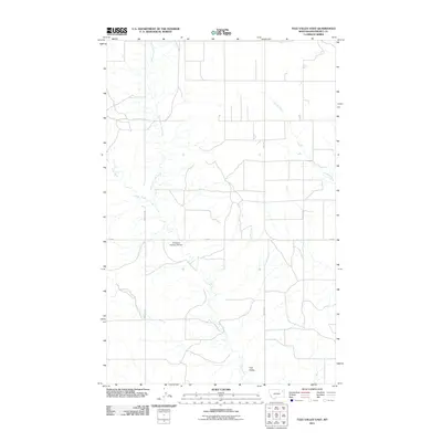
2011 Map of Tule Valley East
USGS Topo · Published 2011About this map
Tule Valley defines the core of this Roosevelt County landscape, where the northern plains of the Wolf Point District are carved by the intricate drainage of the North Fork Tule Creek and the main branch of Tule Creek. This 2011 survey illustrates a region largely shaped by hydraulic management and rural transit, centered on the Structure Number 95 Dam. The network of local routes, including Windyhill Rd and Benrud Rd, provides access to the expansive open reaches between these waterways and the eastward-flowing Chelsea Creek. The mapping of these minor tributaries and rural arteries provides a clear record of the area's modern agricultural and water-resource infrastructure.
Find a feature on this map
8 named features on this map. Tap any name to fly to it.
Don’t see what you’re looking for? This feature index may not catch every label — zoom into the map to look around manually.
Map Details
Editions of this 2011 Tule Valley East Map
This is the sole edition of this map. No revisions or reprints were ever made.
Other maps of this area

1910 · Cuskers
USGS Topo · 1:62,500

1912 · Chelsea
USGS Topo · 1:62,500

1915 · Tule Valley
USGS Topo · 1:62,500

1915 · Cuskers
USGS Topo · 1:62,500

1916 · Wolf Point
USGS Topo · 1:62,500

1954 · Wolf Point
USGS Topo · 1:250,000

1958 · Wolf Point
USGS Topo · 1:250,000

1972 · Chelsea NW
USGS Topo · 1:24,000
1972 · Wolf Point NE
USGS Topo · 1:24,000
1972 · Wolf Point NW
USGS Topo · 1:24,000