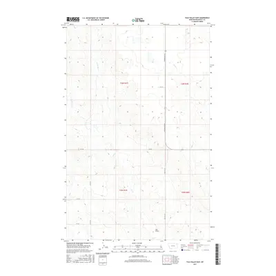
2017 Map of Tule Valley East
USGS Topo · Published 2017About this map
Tule Valley defines the southern portion of this high plains landscape, where the seasonal drainage of Tule Cr cuts through the undulating topography of Roosevelt County. The map details a transition between expansive sections of open range and the network of drainages that feed into the larger regional watershed, including the N Fork Tule Cr and the winding course of Chelsea Cr to the northeast. Transportation in this part of Montana remains oriented around a grid of rural routes, with Powder River Rd and Windy Hill Rd providing the primary north-south corridors through the township lines of T30N and T29N. This 2017 survey reflects the modern configuration of public and private land boundaries in the Wolf Point district, capturing the sparse but critical infrastructure of cattle guards and rural roads like Co Rd 1074 that sustain the local ranching economy.
Find a feature on this map
50 named features on this map. Tap any name to fly to it.
Don’t see what you’re looking for? This feature index may not catch every label — zoom into the map to look around manually.
Map Details
Editions of this 2017 Tule Valley East Map
This is the sole edition of this map. No revisions or reprints were ever made.
Other maps of this area

1910 · Cuskers
USGS Topo · 1:62,500

1912 · Chelsea
USGS Topo · 1:62,500

1915 · Tule Valley
USGS Topo · 1:62,500

1915 · Cuskers
USGS Topo · 1:62,500

1916 · Wolf Point
USGS Topo · 1:62,500

1954 · Wolf Point
USGS Topo · 1:250,000

1958 · Wolf Point
USGS Topo · 1:250,000

1972 · Chelsea NW
USGS Topo · 1:24,000
1972 · Wolf Point NE
USGS Topo · 1:24,000
1972 · Wolf Point NW
USGS Topo · 1:24,000