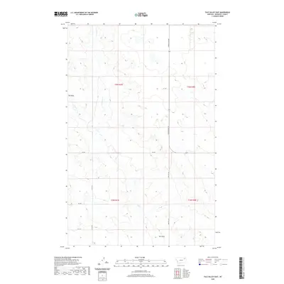
2020 Map of Tule Valley East
USGS Topo · Published 2020About this map
Tule Valley forms the central geographic feature of this section of Roosevelt County, where the high plains are dissected by a network of drainage systems. The landscape is defined by the seasonal flow of N Fork Tule Cr and Tule Cr, which carve through the undulating terrain to create a complex system of draws and coulees. To the northeast, the headwaters of Chelsea Cr mark the divide between local watersheds. This 2020 edition reveals a sparse rural infrastructure typical of eastern Montana’s ranching country. Transportation is limited to a handful of established routes like Powder River Rd and Windy Hill Rd, providing access to isolated homesteads such as the one found along Hs 2 Dr. The map reflects the enduring Public Land Survey System boundaries, including the intersection of townships t30n r47e and t30n r48e.
Find a feature on this map
15 named features on this map. Tap any name to fly to it.
Don’t see what you’re looking for? This feature index may not catch every label — zoom into the map to look around manually.
Map Details
Editions of this 2020 Tule Valley East Map
This is the sole edition of this map. No revisions or reprints were ever made.
Other maps of this area

1910 · Cuskers
USGS Topo · 1:62,500

1912 · Chelsea
USGS Topo · 1:62,500

1915 · Tule Valley
USGS Topo · 1:62,500

1915 · Cuskers
USGS Topo · 1:62,500

1916 · Wolf Point
USGS Topo · 1:62,500

1954 · Wolf Point
USGS Topo · 1:250,000

1958 · Wolf Point
USGS Topo · 1:250,000

1972 · Chelsea NW
USGS Topo · 1:24,000
1972 · Wolf Point NE
USGS Topo · 1:24,000
1972 · Wolf Point NW
USGS Topo · 1:24,000