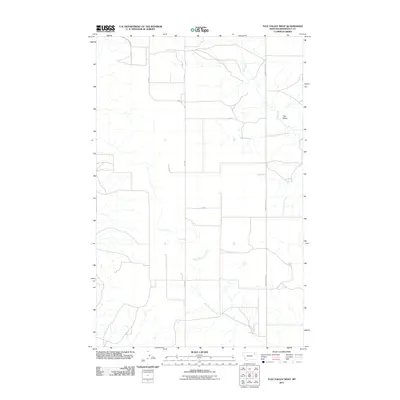
2011 Map of Tule Valley West
USGS Topo · Published 2011About this map
Tule Valley defines this portion of Roosevelt County, where the drainage of the West Fork Tule Creek and the main branch of Tule Creek carve a series of coulees across the Montana landscape. This 2011 survey illustrates a sparse ranching or agricultural environment, marked by a systematic network of county and state roads rather than concentrated settlements. Significant local transit routes, including Hwy 250 and Fas 250, intersect with named tracks like Volt Rd and Powder River RD, which follow the section lines and natural contours of the valley. The map is a clear record of the modern rural infrastructure in the Wolf Point District, showing the precise placement of secondary roads like 17 2045 and 17 2048 that provide access to the remote reaches of the valley floor.
Find a feature on this map
9 named features on this map. Tap any name to fly to it.
Don’t see what you’re looking for? This feature index may not catch every label — zoom into the map to look around manually.
Map Details
Editions of this 2011 Tule Valley West Map
This is the sole edition of this map. No revisions or reprints were ever made.
Other maps of this area

1910 · Todd Lakes
USGS Topo · 1:62,500

1915 · Tule Valley
USGS Topo · 1:62,500

1915 · Oswego
USGS Topo · 1:62,500

1915 · Todd Lakes
USGS Topo · 1:62,500

1916 · Wolf Point
USGS Topo · 1:62,500

1954 · Wolf Point
USGS Topo · 1:250,000

1958 · Wolf Point
USGS Topo · 1:250,000

1972 · Flynn Creek North
USGS Topo · 1:24,000
1972 · Wolf Point NE
USGS Topo · 1:24,000
1972 · Wolf Point NW
USGS Topo · 1:24,000