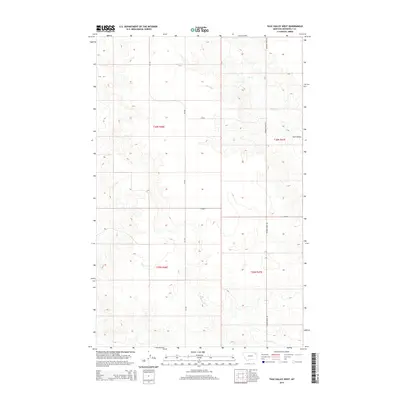
2014 Map of Tule Valley West
USGS Topo · Published 2014About this map
Tule Valley defines the landscape of this northern Montana region, where the drainages of Tule Cr and the W Fork Tule Cr carve through the high plains of Roosevelt County. This 2014 survey captures a sparsely populated territory north of the Missouri River, primarily organized by the Public Land Survey System grids of t30n r46e and t29n r47e. Modern infrastructure is represented by MT-250, which runs north-south through the center of the quadrangle, and the local Powder River Rd. The map illustrates a transitional landscape of coulees and plateaus, typical of the Big Muddy Creek drainage basin, where the primary land use is reflected in the wide-open township boundaries and the lack of concentrated settlements.
Find a feature on this map
9 named features on this map. Tap any name to fly to it.
Don’t see what you’re looking for? This feature index may not catch every label — zoom into the map to look around manually.
Map Details
Editions of this 2014 Tule Valley West Map
This is the sole edition of this map. No revisions or reprints were ever made.
Other maps of this area

1910 · Todd Lakes
USGS Topo · 1:62,500

1915 · Tule Valley
USGS Topo · 1:62,500

1915 · Oswego
USGS Topo · 1:62,500

1915 · Todd Lakes
USGS Topo · 1:62,500

1916 · Wolf Point
USGS Topo · 1:62,500

1954 · Wolf Point
USGS Topo · 1:250,000

1958 · Wolf Point
USGS Topo · 1:250,000

1972 · Flynn Creek North
USGS Topo · 1:24,000
1972 · Wolf Point NE
USGS Topo · 1:24,000
1972 · Wolf Point NW
USGS Topo · 1:24,000