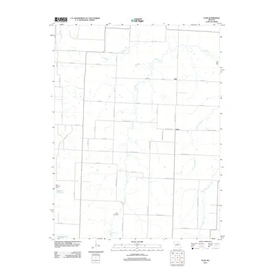
2012 Map of Tulip
USGS Topo · Published 2012About this map
The small communities of Tulip and Saling anchor this rural landscape in northern Missouri, where a complex network of county roads organizes the agricultural terrain. The drainage of Long Branch and its tributaries, including Bee Branch and Scattering Branch, defines the local topography, creating a series of wooded corridors through the open fields. In the southern portion of the area, local water management is highlighted by features such as Cedarlane Farms Lake and Larrabee Lake, both supported by small-scale dams like the Harry Freeman Dam. The map reflects a classic Midwestern township pattern, with farmsteads connected by thoroughfares such as Audrain Road 132 and Co Rd-148. The presence of several named impoundments, including the Sims Lake Dam and Deal Lake Dam, suggests the importance of water conservation and private recreation for the rural residences throughout this region.
Find a feature on this map
47 named features on this map. Tap any name to fly to it.
Don’t see what you’re looking for? This feature index may not catch every label — zoom into the map to look around manually.
Map Details
Editions of this 2012 Tulip Map
This is the sole edition of this map. No revisions or reprints were ever made.
Other maps of this area

1890 · Moberly
USGS Topo · 1:125,000

1917 · Sturgeon
USGS Topo · 1:62,500

1945 · Centralia
USGS Topo · 1:62,500

1952 · Middle Grove
USGS Topo · 1:24,000

1953 · Moberly
USGS Topo · 1:250,000

1953 · Clark
USGS Topo · 1:24,000

1954 · Moberly
USGS Topo · 1:250,000

1957 · Moberly
USGS Topo · 1:250,000

1958 · Tulip
USGS Topo · 1:24,000
1959 · Madison
USGS Topo · 1:24,000