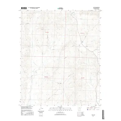
2017 Map of Tulip
USGS Topo · Published 2017About this map
The settlement of Tulip and the small community of Wave anchor this rural landscape in Dallas County, Arkansas. This terrain is defined by the convergence of the W Fork Tulip Cr and the E Fork Tulip Cr, which feed into the larger creek systems alongside Moro Cr and Smith Cr. The presence of the Tulip Cem serves as a significant genealogical marker for the area, reflecting the long-standing community roots here. The map reveals a network of local roads and trails such as Copeland Trl and Penn Trl, suggesting a landscape utilized for timber, local transit, and recreation. The geography is characterized by numerous small tributaries including Tunstle Cr, Hall Cr, and Campground Cr, which dictate the placement of local homesteads and the winding paths of county roads like Dallas 310 and Bevill Rd.
Find a feature on this map
30 named features on this map. Tap any name to fly to it.
Don’t see what you’re looking for? This feature index may not catch every label — zoom into the map to look around manually.
Map Details
Editions of this 2017 Tulip Map
This is the sole edition of this map. No revisions or reprints were ever made.
Other maps of this area

1903 · Camden
USGS Topo · 1:125,000

1953 · El Dorado
USGS Topo · 1:250,000

1955 · Little Rock
USGS Topo · 1:250,000

1956 · Little Rock
USGS Topo · 1:250,000

1957 · El Dorado
USGS Topo · 1:250,000

1958 · El Dorado
USGS Topo · 1:250,000

1960 · El Dorado
USGS Topo · 1:250,000

1960 · Little Rock
USGS Topo · 1:250,000

1964 · Little Rock
USGS Topo · 1:250,000

1965 · Round Hill
USGS Topo · 1:24,000