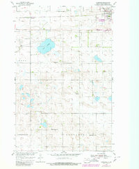
1954 Map of Tunbridge
USGS Topo · Published 1980About this map
The Burlington Northern railroad corridor anchors this survey of central North Dakota, passing through the small settlement of Tunbridge and the outskirts of Rugby. This mid-century landscape is defined by its transition from prairie into the distinct township divisions of Ness, Jefferson, and Tuscarora. The presence of several rural educational institutions, including Brazil School No 1 and Brazil School No 4, alongside the Sand Sch (Abandoned), illustrates the shifting population patterns of the eastern Great Plains as small district schools began to consolidate.
Find a feature on this map
15 named features on this map. Tap any name to fly to it.
Don’t see what you’re looking for? This feature index may not catch every label — zoom into the map to look around manually.
Map Details
Editions of this 1954 Tunbridge Map
2 editions found
Other maps of this area

1953 · Devils Lake
USGS Topo · 1:250,000

1954 · Tunbridge
USGS Topo · 1:24,000

1954 · Berwick
USGS Topo · 1:24,000

1954 · Round Lake
USGS Topo · 1:24,000

1954 · Rugby NW
USGS Topo · 1:24,000

1954 · Leverich
USGS Topo · 1:24,000

1954 · Minot
USGS Topo · 1:250,000

1955 · Rugby
USGS Topo · 1:24,000

1956 · Devils Lake
USGS Topo · 1:250,000

1958 · Minot
USGS Topo · 1:250,000