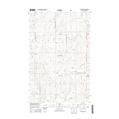
2014 Map of Tunk Mountain
USGS Topo · Published 2014About this map
Okanogan National Forest covers much of this Okanogan County territory, where high-elevation summits like Tunk Mtn and Aeneas Mtn define the landscape. Water sources are vital in this upland environment, with Aeneas Spring and Long Lake providing key landmarks for navigation. The mapping of Forest Service infrastructure is extensive, showing an intricate network of forest development roads such as Nat For Dev Rd 3010 and Nat For Dev Rd 400. Historical travel routes remain visible through the labeling of the Stage Coach Trl and Long Horn Trl, suggesting the movement of goods and livestock through these mountains in earlier eras. This 2014 survey by the U.S. Geological Survey preserves the nomenclature of rural Washington, including many family-named features like Peterson Rd and Sherer Cr.
Find a feature on this map
36 named features on this map. Tap any name to fly to it.
Don’t see what you’re looking for? This feature index may not catch every label — zoom into the map to look around manually.
Map Details
Editions of this 2014 Tunk Mountain Map
This is the sole edition of this map. No revisions or reprints were ever made.
Other maps of this area

1902 · Osoyoos
USGS Topo · 1:125,000

1904 · Osoyoos
USGS Topo · 1:125,000

1952 · Disautel
USGS Topo · 1:62,500

1953 · Omak Lake
USGS Topo · 1:62,500

1954 · Okanogan
USGS Topo · 1:250,000

1957 · Tonasket
USGS Topo · 1:62,500

1957 · Aeneas Valley
USGS Topo · 1:62,500

1958 · Okanogan
USGS Topo · 1:250,000
1980 · Omak Mountain
USGS Topo · 1:24,000
1981 · Barker Mtn
USGS Topo · 1:24,000