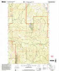
2001 Map of Tunk Mountain
USGS Topo · Published 2004About this map
Okanogan National Forest land dominates this high-elevation terrain, where the peaks of Bannon Mountain and Sneed Mountain overlook a complex network of forest drainage. The Tunk Mountain Lookout serves as a prominent landmark on the western edge of the quadrangle, situated at one of the highest points of the local topography. In the northeast, the Aeneas Valley provides a distinct break in the mountainous landscape, containing several water bodies including Gooseberry Lake, Long Lake, and Round Lake. The area's hydrology is further defined by Patterson Creek and Aeneas Creek, which trace through deep ravines along with several named springs. Resource extraction is noted at a Gravel Pit, while recreational or administrative access is marked by the Beehive Trail winding through the southwestern slopes.
Find a feature on this map
19 named features on this map. Tap any name to fly to it.
Don’t see what you’re looking for? This feature index may not catch every label — zoom into the map to look around manually.
Map Details
Editions of this 2001 Tunk Mountain Map
This is the sole edition of this map. No revisions or reprints were ever made.
Other maps of this area

1902 · Osoyoos
USGS Topo · 1:125,000

1904 · Osoyoos
USGS Topo · 1:125,000

1952 · Disautel
USGS Topo · 1:62,500

1953 · Omak Lake
USGS Topo · 1:62,500

1954 · Okanogan
USGS Topo · 1:250,000

1957 · Tonasket
USGS Topo · 1:62,500

1957 · Aeneas Valley
USGS Topo · 1:62,500

1958 · Okanogan
USGS Topo · 1:250,000
1980 · Omak Mountain
USGS Topo · 1:24,000
1981 · Barker Mtn
USGS Topo · 1:24,000