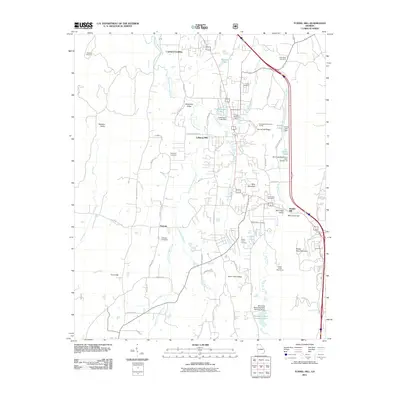
2011 Map of Tunnel Hill
USGS Topo · Published 2011About this map
Tunnel Hill Ridge dominates the eastern corridor of this landscape, anchored by the engineering of the Chetcogeta Mountain Tunnel. This area of north Georgia is defined by a series of north-south trending valleys and ridges, where settlements like Trickum and Mill Creek Valley follow the natural drainage of East Chickamauga Creek and Mill Creek. The map documents a significant concentration of local family history, preserved through numerous burial grounds including Dedmon Cemetery, Dogwood Cemetery, and the Stony Point Cemetery.
Find a feature on this map
76 named features on this map. Tap any name to fly to it.
Don’t see what you’re looking for? This feature index may not catch every label — zoom into the map to look around manually.
Map Details
Editions of this 2011 Tunnel Hill Map
This is the sole edition of this map. No revisions or reprints were ever made.
Other maps of this area

1886 · Dalton
USGS Topo · 1:125,000

1886 · Ringgold
USGS Topo · 1:125,000

1892 · Ringgold
USGS Topo · 1:125,000

1892 · Dalton
USGS Topo · 1:125,000

1897 · Dalton
USGS Topo · 1:125,000

1935 · Catlett
USGS Topo · 1:24,000

1935 · East Ridge
USGS Topo · 1:24,000
1935 · Tiger Creek
USGS Topo · 1:24,000

1935 · Villanow
USGS Topo · 1:24,000

1935 · Ringgold
USGS Topo · 1:24,000