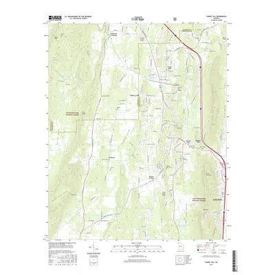
2017 Map of Tunnel Hill
USGS Topo · Published 2017About this map
The Chetogeta Mountain Tunnel pierces through Tunnel Hill Ridge, a defining landmark of this North Georgia corridor where transportation and local industry have long intersected. The town of Tunnel Hill sits at the northern end of this passage, while the southern reaches of the map include the edges of Dalton and the Dalton State Coll campus. The geography is characterized by parallel ridges and valleys, including Taylor Ridge and Dogwood Valley, which dictated the placement of early settlements like Trickum and Mount Vernon. Numerous family-named sites offer significant value for genealogical research, such as Foster Cem, Dedmon Cem, and Stony Point Cem. Water-powered industrial history is represented by labels for Callaway Mill and Hassler Mill, situated along the creek systems that drain the Chattahoochee National Forest.
Find a feature on this map
141 named features on this map. Tap any name to fly to it.
Don’t see what you’re looking for? This feature index may not catch every label — zoom into the map to look around manually.
Map Details
Editions of this 2017 Tunnel Hill Map
This is the sole edition of this map. No revisions or reprints were ever made.
Other maps of this area

1886 · Dalton
USGS Topo · 1:125,000

1886 · Ringgold
USGS Topo · 1:125,000

1892 · Ringgold
USGS Topo · 1:125,000

1892 · Dalton
USGS Topo · 1:125,000

1897 · Dalton
USGS Topo · 1:125,000

1935 · Catlett
USGS Topo · 1:24,000

1935 · East Ridge
USGS Topo · 1:24,000
1935 · Tiger Creek
USGS Topo · 1:24,000

1935 · Villanow
USGS Topo · 1:24,000

1935 · Ringgold
USGS Topo · 1:24,000