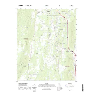
2020 Map of Tunnel Hill
USGS Topo · Published 2020About this map
Tunnel Hill sits at the heart of this topographic study, where the namesake Tunnel Hill Ridge and the historic Chetoogeta Mountain Tunnel define the passage through the northwest Georgia mountains. The landscape transitions from the industrial outskirts of Dalton in the southeast to the rural valleys of Catoosa Co and Whitfield Co. Traditional milling sites like Callaway Mill and Hassler Mill are situated along the valley floors, near the winding paths of East Chickamauga Creek and Mill Cr. The area is densely dotted with family and community burial grounds, including Dedmon Cem, Dogwood Cem, and Stony Point Cem, which provide significant points of reference for genealogical research. Higher elevations such as Rocky Face Mtn and Blue Mtn overlook a mix of agricultural land and the protected boundaries of the Chattahoochee National Forest, illustrating the enduring balance between human settlement and the natural Appalachian terrain.
Find a feature on this map
157 named features on this map. Tap any name to fly to it.
Don’t see what you’re looking for? This feature index may not catch every label — zoom into the map to look around manually.
Map Details
Editions of this 2020 Tunnel Hill Map
This is the sole edition of this map. No revisions or reprints were ever made.
Other maps of this area

1886 · Dalton
USGS Topo · 1:125,000

1886 · Ringgold
USGS Topo · 1:125,000

1892 · Ringgold
USGS Topo · 1:125,000

1892 · Dalton
USGS Topo · 1:125,000

1897 · Dalton
USGS Topo · 1:125,000

1935 · Catlett
USGS Topo · 1:24,000

1935 · East Ridge
USGS Topo · 1:24,000
1935 · Tiger Creek
USGS Topo · 1:24,000

1935 · Villanow
USGS Topo · 1:24,000

1935 · Ringgold
USGS Topo · 1:24,000