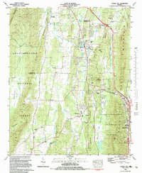
1983 Map of Tunnel Hill
USGS Topo · Published 1983About this map
Tunnel Hill and the surrounding Ridge-and-Valley terrain of North Georgia are defined here by a series of north-south elevations including Taylor Ridge and Rocky Face Mountain. The landscape is bisected by the Seaboard railroad line, which utilizes the Chetoogeta Mountain Tunnel to navigate the steep topography of Tunnel Hill. This corridor has long been a vital transportation artery, evidenced by the clustered development around the town and the newer interstate interchanges near Dalton.
Find a feature on this map
54 named features on this map. Tap any name to fly to it.
Don’t see what you’re looking for? This feature index may not catch every label — zoom into the map to look around manually.
Map Details
Editions of this 1983 Tunnel Hill Map
This is the sole edition of this map. No revisions or reprints were ever made.
Other maps of this area

1886 · Dalton
USGS Topo · 1:125,000

1886 · Ringgold
USGS Topo · 1:125,000

1892 · Ringgold
USGS Topo · 1:125,000

1892 · Dalton
USGS Topo · 1:125,000

1897 · Dalton
USGS Topo · 1:125,000

1935 · Catlett
USGS Topo · 1:24,000

1935 · East Ridge
USGS Topo · 1:24,000
1935 · Tiger Creek
USGS Topo · 1:24,000

1935 · Villanow
USGS Topo · 1:24,000

1935 · Ringgold
USGS Topo · 1:24,000