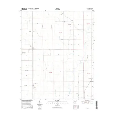
2014 Map of Tupelo
USGS Topo · Published 2014About this map
Tupelo and Weldon serve as the primary hubs in this agricultural landscape within Jackson County, where the low-lying terrain is defined by a complex drainage network. The Cache River meanders through the eastern portion of the map, while artificial and natural waterways like Overcup Ditch, Overcup Slough, and Eight Mile Creek emphasize the historical effort to manage the local water table for farming. The topographic elevation remains remarkably consistent across the quadrangle, with Bowen Ridge providing one of the few subtle rises in the land.
Find a feature on this map
62 named features on this map. Tap any name to fly to it.
Don’t see what you’re looking for? This feature index may not catch every label — zoom into the map to look around manually.
Map Details
Editions of this 2014 Tupelo Map
This is the sole edition of this map. No revisions or reprints were ever made.
Other maps of this area

1935 · Newport
USGS Topo · 1:62,500

1935 · Augusta
USGS Topo · 1:62,500

1935 · Tuckerman
USGS Topo · 1:62,500

1940 · Tilton
USGS Topo · 1:62,500

1953 · Memphis
USGS Topo · 1:250,000

1956 · Memphis
USGS Topo · 1:250,000

1956 · Tilton
USGS Topo · 1:62,500

1957 · Augusta
USGS Topo · 1:62,500

1962 · Newport
USGS Topo · 1:24,000
1962 · Newport
USGS Topo · 1:62,500