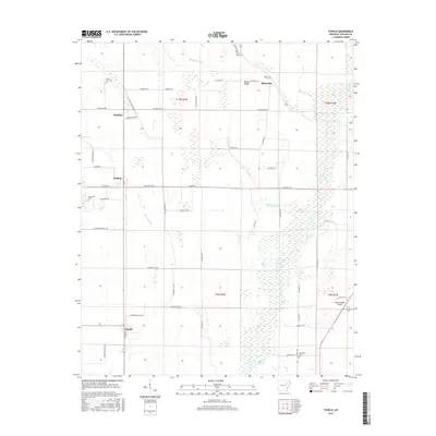
2017 Map of Tupelo
USGS Topo · Published 2017About this map
Tupelo and its surrounding agricultural lowlands are defined by the winding course of the Cache River and an intricate network of drainage features like Overcup Ditch and Overcup Slough. The landscape is a mosaic of cultivated fields and wooded wetlands, characteristic of this region's alluvial geography. Local transit is rooted in the section line roads, including Jackson Road 21 and Straight Rd, which connect small hubs such as Weldon, Shoffner, and Blackville. For researchers, the map provides a clear look at local landmarks and family history sites, including the Breckenridge Airport and several rural burial grounds like Mount Zion Cem and Gourdneck Cem. Notable terrain features such as Bowen Ridge rise subtly above the surrounding bottomlands, while the Eight Mile Cr adds to the complex hydrology of the area.
Find a feature on this map
56 named features on this map. Tap any name to fly to it.
Don’t see what you’re looking for? This feature index may not catch every label — zoom into the map to look around manually.
Map Details
Editions of this 2017 Tupelo Map
This is the sole edition of this map. No revisions or reprints were ever made.
Other maps of this area

1935 · Newport
USGS Topo · 1:62,500

1935 · Augusta
USGS Topo · 1:62,500

1935 · Tuckerman
USGS Topo · 1:62,500

1940 · Tilton
USGS Topo · 1:62,500

1953 · Memphis
USGS Topo · 1:250,000

1956 · Memphis
USGS Topo · 1:250,000

1956 · Tilton
USGS Topo · 1:62,500

1957 · Augusta
USGS Topo · 1:62,500

1962 · Newport
USGS Topo · 1:24,000
1962 · Newport
USGS Topo · 1:62,500