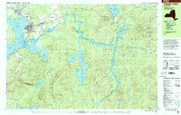
1999 Map of Tupper Lake
USGS Topo · Published 2001About this map
The village of Tupper Lake serves as the focal point for this late-twentieth-century study of the central Adirondacks, situated at the confluence of Raquette Pond and the Raquette River. The community's social and religious infrastructure is well-defined by several institutional landmarks, including Holy Ghost Academy, Mercy General Hospital, and St Alphonsus Cem. To the south, the settlement of Moody sits near the base of Mt Morris, while the eastern portion of the map transitions into the deep wilderness of Adirondack Park within the town of Harrietstown. This landscape is characterized by a dense network of water bodies, from the expansive Simon Pond and Follensby Pond to the secluded Lake Madeleine. The presence of numerous designated campsites and the Ranger Station along the river emphasizes the region's enduring character as a managed wilderness and recreational hub, even as modern infrastructure like the Sewage Disposal and Substation support the growing village center.
Find a feature on this map
58 named features on this map. Tap any name to fly to it.
Don’t see what you’re looking for? This feature index may not catch every label — zoom into the map to look around manually.
Map Details
Editions of this 1999 Tupper Lake Map
This is the sole edition of this map. No revisions or reprints were ever made.
Other maps of this area

1902 · Saranac
USGS Topo · 1:62,500

1904 · Saranac
USGS Topo · 1:62,500

1904 · Santanoni
USGS Topo · 1:62,500

1904 · Long Lake
USGS Topo · 1:62,500

1905 · Saint Regis
USGS Topo · 1:62,500

1907 · Tupper Lake
USGS Topo · 1:62,500

1920 · Childwold
USGS Topo · 1:62,500

1921 · Childwold
USGS Topo · 1:48,000

1922 · Childwold
USGS Topo · 1:62,500

1948 · Ogdensburg
USGS Topo · 1:250,000