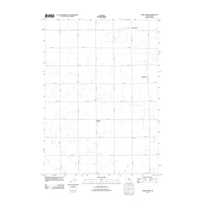
2012 Map of Turkey Ridge
USGS Topo · Published 2012About this map
Turkey Ridge rises above the agricultural grid of Turner County in this 2012 survey, defining the high ground between local drainage basins. The landscape is marked by a precise network of section-line roads, including 290th St and 444th Ave, which connect isolated farmsteads and small crossroads like Pearsons Corner. For those researching family history in the area, the map identifies several distinct burial sites such as Bang Cem, Carlson Cem, Elim Cem, and Ogstad Cem. The hydrologic patterns are shaped by several winding watercourses, notably Turkey Cr and Clay Cr, which cut through the prairie towards Spring Valley. These features reveal a rural community deeply tied to the land and its original survey boundaries.
Find a feature on this map
25 named features on this map. Tap any name to fly to it.
Don’t see what you’re looking for? This feature index may not catch every label — zoom into the map to look around manually.
Map Details
Editions of this 2012 Turkey Ridge Map
This is the sole edition of this map. No revisions or reprints were ever made.
Other maps of this area

1898 · Parker
USGS Topo · 1:125,000

1955 · Sioux Falls
USGS Topo · 1:250,000

1957 · Mayfield
USGS Topo · 1:24,000

1957 · Midway
USGS Topo · 1:24,000

1957 · Jamesville
USGS Topo · 1:24,000

1958 · Sioux Falls
USGS Topo · 1:250,000

1968 · Parker SW
USGS Topo · 1:24,000

1970 · Turkey Ridge
USGS Topo · 1:24,000

1970 · Freeman SE
USGS Topo · 1:24,000
1970 · Irene
USGS Topo · 1:24,000
Featured Places
- Spring Valley, SD
- Spring Valley Township, SD
- Turkey Ridge, SD
- Cameron Hutterite Colony, SD
- Salem Township, SD