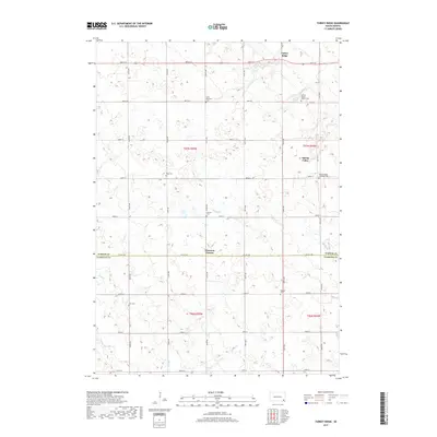
2017 Map of Turkey Ridge
USGS Topo · Published 2017About this map
Turkey Ridge rises above the surrounding plains along the boundary of Turner and Yankton Counties, anchoring a rural landscape defined by deep family roots and communal burial grounds. In this 2017 survey, the settlement of Spring Valley is flanked by several denominational landmarks, including Spring Valley Baptist Cem and Spring Valley Lutheran Cem. The map reveals a high density of small, family-named cemeteries such as Bang Cem, Carlson Cem, Elim Cem, and Ogstad Cem, offering a detailed spatial record for genealogists tracing the early homesteading families of the region. The drainage patterns of Turkey Cr, Clay Cr, and Smoky Run cut through the gridded section lines of the Public Land Survey System, illustrating how natural hydrology continues to intersect with the rigid township and range boundaries of t97n r55w and t96n r54w.
Find a feature on this map
36 named features on this map. Tap any name to fly to it.
Don’t see what you’re looking for? This feature index may not catch every label — zoom into the map to look around manually.
Map Details
Editions of this 2017 Turkey Ridge Map
This is the sole edition of this map. No revisions or reprints were ever made.
Other maps of this area

1898 · Parker
USGS Topo · 1:125,000

1955 · Sioux Falls
USGS Topo · 1:250,000

1957 · Mayfield
USGS Topo · 1:24,000

1957 · Midway
USGS Topo · 1:24,000

1957 · Jamesville
USGS Topo · 1:24,000

1958 · Sioux Falls
USGS Topo · 1:250,000

1968 · Parker SW
USGS Topo · 1:24,000

1970 · Turkey Ridge
USGS Topo · 1:24,000

1970 · Freeman SE
USGS Topo · 1:24,000
1970 · Irene
USGS Topo · 1:24,000
Featured Places
- Spring Valley, SD
- Spring Valley Township, SD
- Turkey Ridge, SD
- Cameron Hutterite Colony, SD
- Salem Township, SD