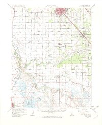
1962 Map of Turlock
USGS Topo · Published 1963About this map
The Southern Pacific and Tidewater Southern rail lines define the transport corridor through Turlock and Delhi, connecting the growing agricultural hubs of the San Joaquin Valley. This mid-century survey illustrates the intricate irrigation network supporting the region, where the San Joaquin River and Merced River converge amidst a landscape of duck ponds and sloughs. Small agrarian centers like Hilmar, Irwin, and Stevinson are anchored by local institutions such as Hilmar High Sch and Merquin Sch.
Find a feature on this map
63 named features on this map. Tap any name to fly to it.
Don’t see what you’re looking for? This feature index may not catch every label — zoom into the map to look around manually.
Map Details
Editions of this 1962 Turlock Map
2 editions found
Other maps of this area

1915 · Westport
USGS Topo · 1:31,680

1916 · Mitchell School
USGS Topo · 1:31,680

1916 · Crows Landing
USGS Topo · 1:31,680

1916 · Cressey
USGS Topo · 1:31,680

1916 · Montpellier
USGS Topo · 1:31,680

1916 · Denair
USGS Topo · 1:31,680

1916 · Ceres
USGS Topo · 1:31,680

1917 · Turlock
USGS Topo · 1:31,680

1917 · Newman
USGS Topo · 1:31,680

1918 · Arena
USGS Topo · 1:31,680