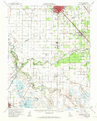
1962 Map of Turlock
USGS Topo · Published 1963About this map
The confluence of the San Joaquin River and the Merced River anchors this 1962 topographical study of the Central Valley. The landscape is defined by an intensive network of irrigation canals, including the Tidewater Canal and numbered laterals like Lateral No 6, which support the agricultural settlements of Hilmar, Irwin, and Stevinson. To the north, the growing urban center of Turlock is bisected by the Southern Pacific railroad and U.S. 99, showing the city's early development patterns and industrial sidings.
Find a feature on this map
67 named features on this map. Tap any name to fly to it.
Don’t see what you’re looking for? This feature index may not catch every label — zoom into the map to look around manually.
Map Details
Editions of this 1962 Turlock Map
2 editions found
Other maps of this area

1915 · Westport
USGS Topo · 1:31,680

1916 · Mitchell School
USGS Topo · 1:31,680

1916 · Crows Landing
USGS Topo · 1:31,680

1916 · Cressey
USGS Topo · 1:31,680

1916 · Montpellier
USGS Topo · 1:31,680

1916 · Denair
USGS Topo · 1:31,680

1916 · Ceres
USGS Topo · 1:31,680

1917 · Turlock
USGS Topo · 1:31,680

1917 · Newman
USGS Topo · 1:31,680

1918 · Arena
USGS Topo · 1:31,680