
1964 Map of Turnbaugh Corner
USGS Topo · Published 1966About this map
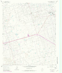
The industrial and ranching landscape of West Texas is documented in high detail on this mid-1960s survey. The area is dominated by the Dom Oil Field and the Lawson Oil Field, characterized by an extensive network of pipelines and aqueducts that crisscross the terrain. Vital infrastructure supporting the local petroleum economy includes the Goldsmith Plant and a Gasoline Plant, while the presence of a Pumping Sta and a Water Tank highlights the complex resource management required in this environment.
Find a feature on this map
19 named features on this map. Tap any name to fly to it.
Don’t see what you’re looking for? This feature index may not catch every label — zoom into the map to look around manually.
Map Details
Editions of this 1964 Turnbaugh Corner Map
2 editions found
Other maps of this area

1954 · Hobbs
USGS Topo · 1:250,000

1954 · Pecos
USGS Topo · 1:250,000

1957 · Pecos
USGS Topo · 1:250,000

1958 · Hobbs
USGS Topo · 1:250,000

1964 · Douro
USGS Topo · 1:24,000

1964 · Red Lakes
USGS Topo · 1:24,000

1965 · Goldsmith
USGS Topo · 1:24,000

1967 · North Cowden
USGS Topo · 1:24,000

1968 · Coyote Corner
USGS Topo · 1:24,000

1971 · Notrees
USGS Topo · 1:24,000