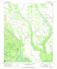
1967 Map of Turner
USGS Topo · Published 1968About this map
The White River National Wildlife Refuge dominates the southwestern corner of this landscape, where the White River meanders through a dense network of oxbows and bayous including Buck Lake, Moon Lake, and Indian Bayou. The terrain transitions from these low-lying bottomlands toward the agricultural flats of the Fifth Principal Meridian. Scattered rural settlements and small crossroads define the human geography of the late 1960s, notably at Turner and Cross Roads. A high concentration of community landmarks, such as Valley Grove Ch and the Turner Sch, suggests a series of established rural neighborhoods. Of particular interest to historians is the Indian Mound located near Indian Bay, indicating the long-standing human presence in this riverine environment. The map also meticulously records several family-named cemeteries, including Israel Cem and Connells Cem, which serve as vital touchstones for genealogical research in this region of Monroe and Phillips counties.
Find a feature on this map
51 named features on this map. Tap any name to fly to it.
Don’t see what you’re looking for? This feature index may not catch every label — zoom into the map to look around manually.
Map Details
Editions of this 1967 Turner Map
2 editions found
Other maps of this area

1939 · Modoc
USGS Topo · 1:62,500

1939 · Indian Bay
USGS Topo · 1:62,500

1940 · Marvell
USGS Topo · 1:62,500

1940 · Holly Grove
USGS Topo · 1:62,500

1948 · Helena
USGS Topo · 1:250,000

1948 · Modoc
USGS Topo · 1:62,500

1950 · Helena
USGS Topo · 1:250,000

1954 · Indian Bay
USGS Topo · 1:62,500

1955 · Helena
USGS Topo · 1:250,000

1956 · Marvell
USGS Topo · 1:62,500